Satellites- Understanding How They Work! MS
Topic outline
-
Satellites- Understanding How They Work !
 :
:Written By: Frances Dellutri, Middle School/Intermediate Level EIS Education Team, April 2016
EIS Topic: Atmosphere, Centripetal Force, Computers, Mathematics, Micro-gravity, Free-fall, Orbital Mechanics, Physics, Satellites, Spacecraft, Weightlessness
Grade (Age) Level: Grades 5-8 (Ages 10-13)
Key Topics Associated with Standards: Collecting, Analyzing and Interpreting Data; Gravitational Interactions; Forces and Motion, Relationship between Energy and Forces
This project will acquaint you and students with what satellites are, the forces that act on satellites, types of orbits satellites can be found circling Earth, and how to track satellites from the ground.The NSS Enterprise orbiter will be tracked upon launch in 2020 carrying 100+ student experiments! Learn about tracking satellites by using the Trek-A-Sat Activity.
Index:
1. What do you know about gravity?
2. Introduction to forces and gravitational pull here on Earth!
3. Understanding Centripetal Force
4. What is Weightlessness all about, anyway!
5. Satellites
6. Understanding satellite orbits.
7. Exit slip - Let's find out what you learned.-
Forum
-
-
There are various orbits in to which satellites can be launched. The satellite's purpose determines the best orbit for the satellite. Some satellites are making a survey of Earth and need to be in particular positions to gather the data. Some satellites convey communication information through a network of satellites and they will need to be oriented in advantageous positions around Earth to give their most efficient and effective performance . The various types of orbits are discussed and illustrated below:
Lynne Zielinski contributes the graphics.
Satellite Orbits
This information is adapted and expanded from "Looking at Earth From Space", a Teacher's Guide with Activities for Earth and Space Science, 1994, available from NASA Education Resource Centers.Satellites can operate in several types of Earth orbit. The most common orbits for environmental satellites are geostationary and polar, but some instruments also fly in inclined orbits. (Other types of orbits are possible, such as the Molniya orbits commonly used for Soviet spacecraft and not described in this lesson.)
Geostationary Orbits
A geostationary (GEO=geosynchronous) orbit is one in which the satellite is always in the same position with respect to the rotating Earth. The satellite orbits at an elevation of approximately 35,790 km (~22,000 miles) because that produces an orbital period (time for one orbit) equal to the period of rotation of the Earth (23 hrs, 56 mins, 4.09 secs). By orbiting at the same rate, in the same direction as Earth, the satellite appears stationary (synchronous with respect to the rotation of the Earth).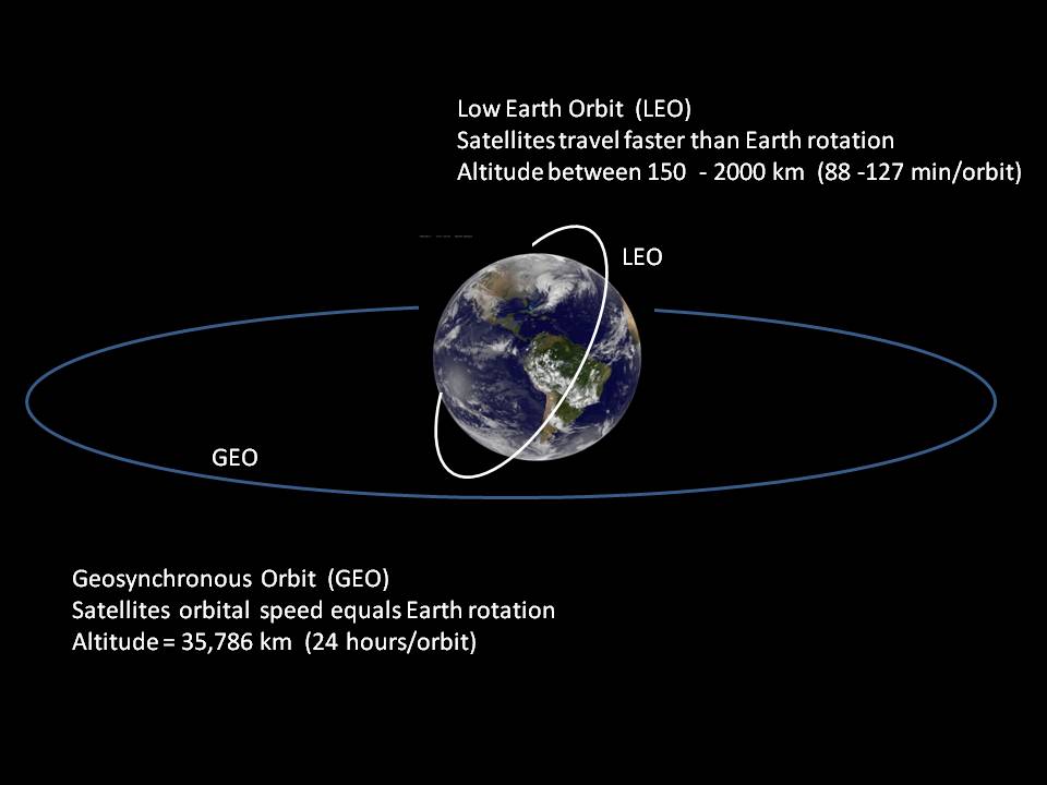
Geostationary satellites provide a "big picture" view, giving great coverage of weather events. This information is critical when monitoring severe local storms and tropical cyclones.
The geostationary satellites are in the same plane as the Earth's rotation, which is an equatorial plane. The position of the orbit gives a limitation in the polar region images and they become distorted with poor spatial resolution.
Take a look at the " View from a Geostationary Weather Satellite" at the end of this section.
Polar-orbiting satellites provide a more global view of Earth, circling at near-polar inclination (the angle between the equatorial plane and the satellite orbital plane -- a true polar orbit has an inclination of 90 degrees). Orbiting at an altitude of 700 to 800 km (430 - 500 mi), these satellites are able to gather information from parts of the world that are very difficult to analyze from the ground. For example, McMurdo, Antarctica, can be seen on days 11-12 of the 14 daily NOAA polar-orbiter passes.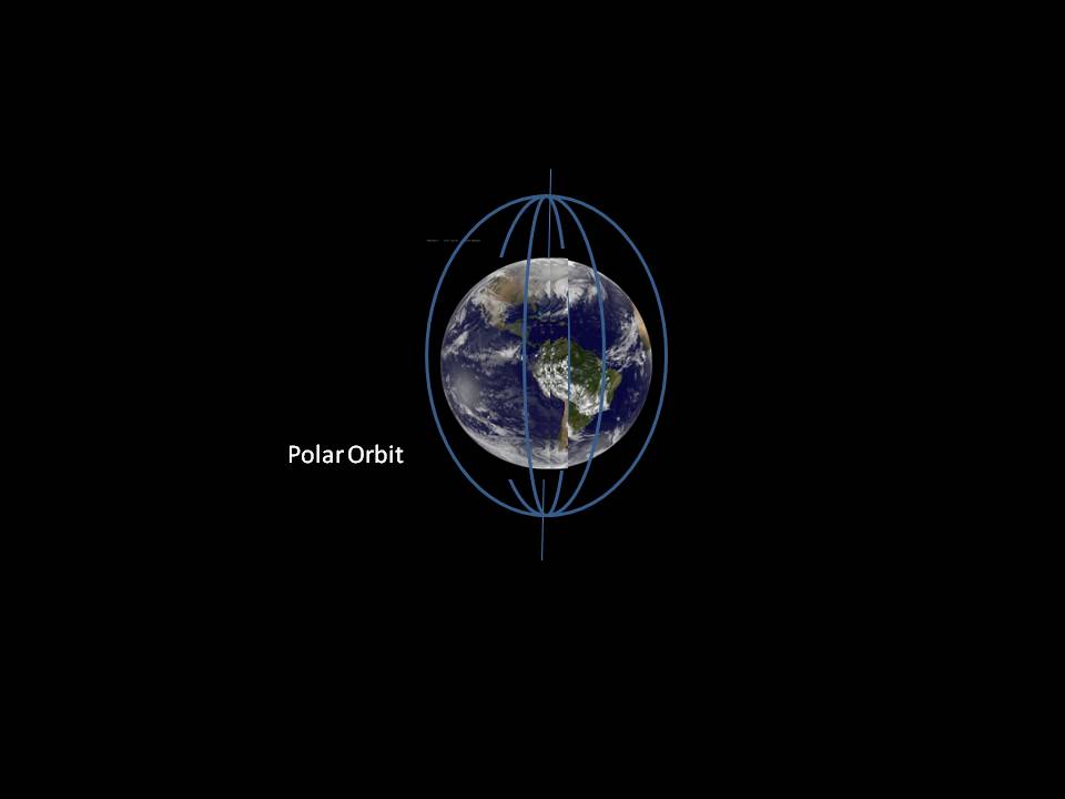 Polar Orbits
These satellites operate in a sun-synchronous orbit. The satellite passes the equator as well as each latitude at the same local solar time each day. This means that the satellite will be passing overhead at about the same solar time throughout all the seasons of the year. The polar orbiting satellites give regular data collection at consistent times as well as long-term comparisons of data collected. The orbital plane of a sun-synchronous orbit must also rotate approximately one degree per day to deep pace with the earth's surface. Examples of polar satellites are: Terra, Aqua, and NPP satellites (which collect data on long term climate change and short term weather changes.)
Inclined Orbits
Inclined orbits fall between those above. They have an inclination between 0 degrees (equatorial orbit) and 90 degrees (polar orbit). These orbits may be determined by the region on Earth that is of most interest (i.e., an instrument to study the tropics may be best put on a low inclination satellite), or by the latitude of the launch site. The orbital altitude of these satellites is generally on the order of a few hundred km, so the orbital period is on the order of a few hours. These satellites are not sun-synchronous, however, so they will view a place on Earth at varying times. You can find several satellite tracking tools here which will show you what various orbits look like.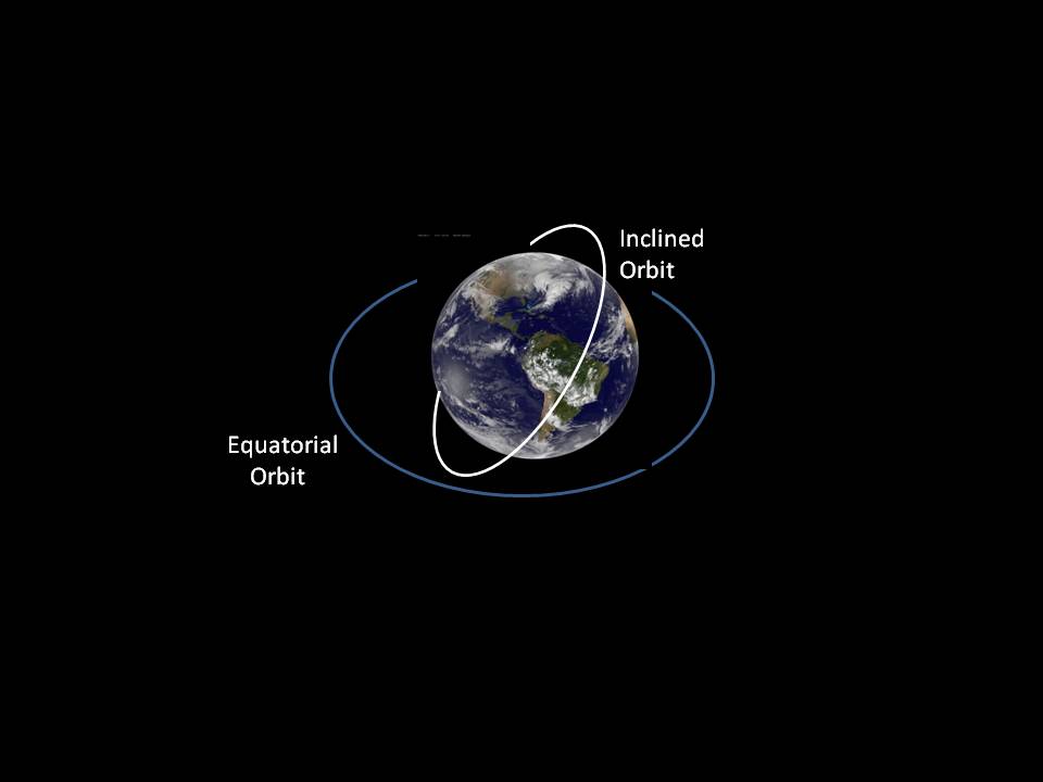
The National Space Society's NSS Enterprise is currently planned to be in a LEO orbit and will launch in 2020-2021. You will be able to track the satellite during its orbit and prior to its retrieval. Keep posted on the actual dates of deployment, orbit, and recovery! To learn how to track a satellite, take a look at the Trek-A-Sat project link below:
-
Watch this video showing the movement of Tropical Storm Danielle in the Gulf of Mexico June 18 - 20, 2016. Danielle started off the east coast of Mexico and went inland. It did not strengthen into a hurricane.
The GOES satellite orbits the earth in the same place as the Earth rotates, so the satellite gets data from the same area on Earth. This is very important for weather satellites!
-